Mount Everest

Travel Guide Asia Mount Everest
Introduction
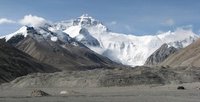
Mount Everest from Basecamp
No mountain in the world has a greater attraction on climbers than the highest of them all. Mount Everest is situated on the border of Nepal and China's Tibetan Autonomous Region.
Mount Everest attracts many climbers, some of them highly experienced mountaineers. There are two main climbing routes, one approaching the summit from the southeast in Nepal (known as the "standard route") and the other from the north in Tibet, China. While not posing substantial technical climbing challenges on the standard route, Everest presents dangers such as altitude sickness, weather, and wind, as well as significant hazards from avalanches and the Khumbu Icefall. As of 2016 there are well over 200 corpses on the mountain, some of which serve as landmarks.
For the Nepalese government it's a major source of income, as each climber needs to pay up to US$25,000 to obtain a permit to be able to climb the mountain. Expeditions also hire a lot of local people as carriers or guides to haul the equipment needed for a successful expedition to the base camp.
![]()
Brief History
Discovery
In 1802, the British began the Great Trigonometric Survey to map the entire region of India. The survey reached the foothills of the Himalayas in the 1830s, and observations on a peak, simply labelled as peak 'b', began in 1847. It took several years of surveys to determine the height of the peak. In the early 1850s, the surveyor team had re-designated the peak as Peak XV, and it had, by then, been identified by the team as possibly the world's highest. An official announcement of this finding was delayed for several years while the calculations were repeatedly verified. Finally, in 1856, the height of Peak XV was publicly declared to be 29,002 ft (8,839.8 metres).
Naming
It was a challenge for the survey team to name the mountain. There were many different local names existed –Chomolungma or Qomolangma in Tibet; Deodungha in Darjeeling - and they were unable to find any commonly used local name. Andrew Waugh, the Surveyor-General of India at that time, argued that it would be difficult to favour one specific name over all others. So he decided to name Peak XV after his predecessor, George Everest. George Everest was against the decision of his successor because his name could not be written in Hindi nor pronounced by "the native of India". Despite the objections, the Royal Geographical Society in 1865 officially adopted Mount Everest as the name for the highest mountain in the world. In the early 1960s, the Nepal government gave the mountain the official name Sagarmāthā (meaning head of the sky), a name that had not previously been used.
Ascents
The first successful ascent of Mount Everest was accomplished on 29 May 1953 by New Zealander Sir Edmund Hillary and Tenzing Norgay, a Sherpa from Nepal. Both men refused to tell to the world who actually reached the summit first, but Tenzing revealed a few years later that Hillary had put his foot on the summit first. There are people who believe that the mountain was already climbed in 1924 by George Mallory and Andrew Irvine, but both died on the mountain during the expedition. It is however generally believed that the men did not reach the summit, and the recovery of the body of George Mallory in 1999, seem to support the theory that both men did not climb all the way to the summit.
Some other successful first climbs were by Junko Tabei from Japan (the first woman on the top) in 1975, the first climb without the use of oxygen by Reinhold Messner and Peter Habeler in 1978 (a story recorded in the book "Everest" by Reinhold Messner himself), and in 1980 Reinhold Messner was the first solo-climber to ascent the summit without the help of a huge expedition.
Recent
In April 2010, both China and Nepal agreed on the official height of Mount Everest. Both countries, which shared the mountain, now recognised Mount Everest as being 8,848 metres tall.[1] This official height included the snow cap. Nepal also recognised the rock height as 8,844 metres, a claim made by China.
![]()
Geography
Mount Everest is part of the Mahalangur Himal, the subrange of the Himalaya mountain range, which spans along the border between Nepal and Tibet. The height of Mount Everest is officially recognised by China and Nepal as 8,848 metres including the snow cap.[1] Both countries also recognised the rock height as 8,844 metres. However, geologists say that both estimated could be wrong as the shifting continental plates gradually pushed the mountain higher. Mount Everest is in the Mahalangur Range. The international border between China (Tibet Autonomous Region) and Nepal runs across Everest's summit point. Nearby peaks include Lhotse, 8,516 metres; Nuptse, 7,855 metres, and Changtse, 7,580 metres among others. Another nearby peak is Khumbutse, and many of the highest mountains in the world are near Mount Everest.
![]()
Getting There
Fly to Lukla Airport from Kathmandu. There are several airlines operating dozens of flights everyday. Among them, Tara Air and Agni Air are generally considered the most reliable airlines plying the route. Sita Air also operates two flights every morning from Kathmandu to Lukla at 07:00 and 08:20. The flight takes around 25 minutes. During the summer rainy season, there may be substantial delays of flights, even a wait of one week is not unheard of. For the return journey, the flights leave Lukla at 07:40 and 09:00. Helicopter charter service is also available on demand and mostly used for rescue operation. Beware that airline safety regulations in Nepal are poor, and there is a chance you may get involved in a plane crash.
Alternatives are to fly to Phaplu airport, 2-3 trekking days south of Lukla, or to walk in from Jiri, which is 5-7 trekking days west of Lukla. These alternatives take more time and therefore are less popular, but are very peaceful and pleasant - and much safer than flying into Lukla.
Just after the village of Monju, there is check point for entering the Sagarmatha National Park. You will need to show your passport and pay a 3,000 Rs entry fee.
Nepal
As a normal traveler, with the wish to see the Mount Everest, you can book hikes with a couple of companies in Kathmandu in Nepal. There are a number of organised tours from 11 to 19 days, that take you from Jiri to Everest Base camp and back again. Be aware that this include hiking days with around 7 to 8 hours of walking every day, so you have to be reasonably fit to be able to complete the trek successfully.
If you only want to catch a glimpse of Mount Everest and the Himalayas, you can book flights from Kathmandu, that make a roundtrip of about 2 hours to the Everest region and back to Kathmandu.
Tibet
On the Tibetan side of the mountain it is easier to get to the basecamp. You can head to Rongbuk Monastery and from there it is only a 12 km hike to the basecamp on that side of the mountain.
![]()
Everst Base Camp Trek
=
Below is an itinerary from Lukla Airport to Everest Base Camp and all points in between.
- Day 1 - Lukla airport (about US$130 from KTM) to Monju (2,800 metres): Pass directly through the village of Lukla (there is no compelling reason to stop here, though it is a good place to have breakfast/lunch.) and follow the path to Namche. There will no doubt be a string of porters carrying goods up to the Sherpa capital, so the route is easy to locate. The first village after Lukla is Chheplung, and further down the trail, you will pass through Ghat and Phakding. Both these villages have a good selection of lodges and restaurants and are conveniently located for taking a meal break. However, if you still have enough stamina, it is advisable to press on to Monju (about 90 minutes to two hours from Phakding) to spend the night as this will give you a good start for the steep ascent to Namche the following morning. Lukla to Monju 10 kilometres and 6.5 hours.
- Day 2 - Monju to Namche: After passing through the Sagarmatha Park entrance (3,000 Rs for foreigners), the trail passes through the village of Jorsale and then along the river. You will cross two bridges before beginning the steep ascent to Namche, which can take up to three hours to complete. Be aware that there are no tea houses or lodges on this path, so ensure that you have ample water to get you to the top. In addition, you are now heading into a high altitude area, so take it easy. Even the fittest people are prone to altitude sickness. Monju to Namche 5 kilometres and 3 to 4 hours, almost all uphill.
- Days 3 and 4 - Namche Bazaar (3,440 metres): It is recommended to take an altitude acclimatisation rest day in Namche. Although no more than a village, the Sherpa capital has two museums, several internet cafes, and, at last count, two pizza houses and three cafes (locally known as bakeries), so there is much to keep you occupied during your stay here. Namche also has two official money changers, so it is a good place to stock up on local currency for the days ahead (NB: Lodges and restaurants in Khumbu only accept Nepali Rupees). There is also a reasonable selection of English books, though the prices are higher than in Kathmandu.
- During your acclimatization rest day, you might like to visit neighboring villages. Khumjung (3,790 metres) is over the hill directly behind Namche, and takes about one and a half to two hours to reach. There are several sights in the village (See listings below) and a few lodges and cafes. Khunde is a short walk from Khumjung. Getting there: Take the Tengboche trail, then at the top of the hill above Namche, near the huge mani stone and just past the bank, head straight up the mountain - the wider path to the right goes to Tengboche. After a steep climb, you will arrive at an airstrip. Cross this and rejoin the path at the other side. After a short distance you'll pass a stupa. From there, take the paved path down the hill. Soon you will see the playground and school buildings of Khumjung Hillary School. Thame (3,750 metres) is a more traditional village that is about a two and a half hour to three hour walk from Namche. Getting there: Leave Namche on the path that passes the ochre colored Namche Monastery (Namche Gompa). From here, it is a relatively flat walk that takes in some very pleasant scenery. The first hamlet on the route is 'Phurte,' identified by the forest nursery, and then 'Tesho.' The water that runs through 'Tesho' comes directly from 'Mount Khumbi Yui Lha' - the most sacred mountain to the Sherpas - so there are several retreat huts built into the niches here. Thame is the next village on the trail, and a good place to take lunch. Thame has a few lodges and is home to one of Khumbu's oldest monasteries. This trail is also the traditional route to Tibet, so don't be surprised to encounter caravans of yaks led by long-haired Tibetan merchants on your walk.
- Day 5 - Namche to Tengboche (3,870 metres): After a short but steep climb out of Namche Bazaar, then walk on a fairly level trail to the villages of Kenjuma and Sanasa. Here there are extensive displays of souvenirs to tempt you and food and drinks. The Ama Dablam Lodge in Kanjuma has some good food and the sitting area out front offers uninhibited views of Ama Dablam. In addition, the lodge reputedly has the best selection of jewellery for sale in the whole of Khumbu, so if you don't plan to return this way, pick out a few light souvenirs - they will forever remind you of this sun-blessed place and the sparkling snow capped peak of Ama Dablam. After a short while, the trail descends to the level of the Dudh Koshi River, and you will pass a few hamlets and cross several bridges. Then at the hamlet of Phunki Thanga (marked by its water driven prayer wheels), the trail ascends steeply. There are no tea houses or lodges on this stretch, so take some refreshment in Phunki Thanga and stock up on water for the one and a half to two hour climb to Tengboche. NB: Take it easy going up here. The air is thinner than you are aware! You want to avoid mountain sickness.
- Day 6 - For those heading for Everest, the trail passes through the villages of Deboche (here, there is a small nunnery on the left - definitely worth a visit), Pangboche (3,860 metres), Dingboche and finally Periche (4,240 meters). All these villages offer food and lodgings. Pangboche (especially Upper-Pangboche, where the local monastery is located) is, however, probably the most pleasant as it is surrounded by trees. So, if you decide to take the journey slowly, this is the best place to rest and relax. For those heading for Island Peak Trek and/or the Lhotse Glacier, your final destination will be Chukhung. As this is further than Periche, you will definitely need to stop the night in Pangboche or Dingboche.
- Day 7 - In Periche, you will need to take a day to acclimatize to the high altitude. Take short, slow walks around the village, marvel at the peaks and dig out the book you bought in Namche, but whatever you do, don't push it at this point. If you begin to feel unwell, inform your guide or lodge owner and return as quickly as possible to a lower altitude. The experts say hike high sleep low. So some Nepal experts recommend that if you are feeling well, to hike each day to a higher elevation than you will sleep.
- Day 8 - Periche to Lobuche (4,930 metres): Spend the night in this small village packed with tourists. There are several lodges at this village but not much to do here besides eat and sleep. Often trekkers entering Lobuche will find the lodges full and may have to share a room with a stranger or sleep in the common room. Even if you have a room, you may be asked by the lodge owner to share it with someone.
- Day 9 - Lobuche to Gorak Shep (5,160 metres): This is a fairly easy hike and should take about 3 hours. You can take a short side-trip and visit the Everest Pyramid, a weather station built by Italians. In Gorak Shep threr is a small, usually frozen lake. This village now has three lodges: Himalaya Lodge, Snowland Lodge and the Kala Pattar lodge. Gorak Shep will be your base to visit the Everest Base Camp (5,380 meters) and to climb the hill behind the lodges called Kala Patthar (5,643 metres) with great views of Mt. Everest and surrounding mountains.
Alternate return trip - From Lobuche, the trail via Cho La (5,370 metres) to the wonderful Gokyo valley with its glacier lakes and fine views offers some stunning scenery and is not as crowded as that to Everest.
![]()
Climbing
Mt. Everest has two main climbing routes, the southeast ridge from Nepal and the north ridge from Tibet, as well as many other less frequently climbed routes. Of the two main routes, the southeast ridge is technically easier and more frequently used. It was the route used by Edmund Hillary and Tenzing Norgay in 1953 and the first recognised of 15 routes to the top by 1996. This was, however, a route decision dictated more by politics than by design, as the Chinese border was closed to the western world in the 1950s, after the People's Republic of China invaded Tibet.
Most attempts are made during May, before the summer monsoon season. As the monsoon season approaches, the jet stream shifts northward, thereby reducing the average wind speeds high on the mountain. While attempts are sometimes made in September and October, after the monsoons, when the jet stream is again temporarily pushed northward, the additional snow deposited by the monsoons and the less stable weather patterns at the moons' tail end make climbing extremely difficult.
![]()
External Links
References
- 1.1 1.2 Nepal and China agree on Mount Everest's height. BBC News (8 April 2010). Retrieved on 2010–04–10.
Contributors
 Utrecht (73%)
from https://utrecht.travellerspoint.com Hien (17%)
Mount Everest Travel Helpers

Mountain Sherpa
Ask Mountain Sherpa a question about Mount EverestMountain Sherpa Trekking specialized for Mount Everest base camp trek in Nepal. We are Local Sherpa guide from mount Everest region. So, We can answer your question any time with latest update. any question?? email: [email protected]
Thank you,
Sumba Sherpa
This is version 28. Last edited at 7:08 on Aug 2, 17 by Utrecht. 12 articles link to this page.

Except where otherwise noted, content of this article is licensed under a Creative Commons Attribution-ShareAlike 3.0 License