United States National Parks

Travel Guide United States United States National Parks
Introduction
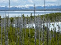
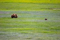
Landscape of Yellowstone
© Utrecht
The United States are one of the role models of how to create and maintain national parks. It has 130 years of experience since the first national park in the world opened here in 1872: Yellowstone National Park. The Sequoia and Yosemite National Parks followed in 1890 and nowadays, there are 58 official national parks in the USA. The newest national park is Great Sand Dunes, established in 2004. National parks must be established by an act of the United States Congress and are maintained by the National Park Service. National parks usually have a variety of natural resources over large areas and many of them had been previously protected as National Monuments. Seven national parks are paired with a National Preserve, six of which are in Alaska. The largest can be found here: Wrange-St. Elias which covers around 32,000 square kilometres. The smallest is Hot Springs with just 24 square kilometres. The national parks are located in 27 states but there are also national parks in American Samoa and the United States Virgin Islands. Alaska and California have 8 national parks, followed by Utah with 5 and Colorado with 4. The most-visited national park is Great Smoky Mountains, with over 9 million visitors, followed by the Grand Canyon with over 4 million. 14 national parks are designated World Heritage Sites. Apart from the national parks, monuments and preserves there are also state parks, monuments and preserves as well many historical monuments, scenic byways and lots of other protected areas or heritage. Check the NPS website for more information.
![]()
Acadia National Park
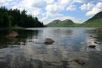
Acadia National Park - Maine
Acadia National Park is a National Park located in the U.S. state of Maine. It reserves much of Mount Desert Island, and associated smaller islands, off the Atlantic coast. Created as Lafayette National Park in 1919, it was renamed Acadia in 1929 and is the oldest National Park east of the Mississippi River. The park includes mountains, an ocean shoreline, woodlands, and lakes. In addition to Mount Desert Island, the park comprises much of the Isle au Haut, parts of Baker Island, and a portion of the Schoodic Peninsula on the mainland. The park is home to some 40 different species of mammalian wildlife. Among these are red and gray squirrels, chipmunks, white-tailed deer, moose, beaver (Castor canadensis), porcupine, muskrats, foxes, coyote, bobcats, and black bears. Many other marine species have been observed in the surrounding area and waters.
![]()
American Samoa National Park
The American Samoa National Park has a lot to offer for those travellers keen on the very best of nature in the world. The shorelines, reefs and rainforest are of outstanding beauty. The park actually is actually divided into three parks on four separate islands! Lata Mountain on Ta’u has wild and remote forests, free-flowing streams, and rugged coastline. It occupies 2,160 hectares of land with highlights including a spectacular escarpment along the southern side and cliffs up to 900 metres high. The the impressive Judds Crater tops things of. To add, the lowlands and rainforests are home to fruit bats and many native birds. Islands like Ofu and Olosega have are a bit different in that they have the most accessible coral reefs and also more and longer white-sanded beaches against a dramatic background. The fourth island, Tutuila even has forests accesible by car and also great wildlife and o course a scenic coastline. Basically, all four islands are actually extinct volcanoes heavily eroded to rugged peaks when the Pacific Plate moved and eruptions from within the earth together made this gift of nature.
![]()
Arches National Park
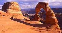
Delicate Arch, Arches National Park, Utah
© jjstroke
Arches National Park: the name says it all. This national park, located in southeastern Utah boasts the highest density of rock arches anywhere on this planet: over 2,500 in an area of just about 116 square miles. While some of them might be just a few feet, others like the Landscape Arch stretches over 300 feet (almost 100 metres). Combined with magnificent rock-desert landscape and snowcapped peaks (at least in winter) in the background, it doesn't come as a surprise that this is one of the most favorite parks in the southwest of the USA and also a favorite place for movie makers! Although there probably will be arches forever, arches do come and go under the constant process of erosion - the influence of water and wind, freezing temperatures at night and hot days.
![]()
Badlands National Park
Photo not found
Badlands National Park is a national park in southwestern South Dakota. This park is marked by rugged terrain and formations that resemble a science fiction landscape of another world. These rock formations take on the shapes of domes, twisted canyons and slanted walls, often striped in different colors. The formations contrast sharply with the rolling hills and prairies in which they stand. In addition to the rock formations, the park contains the largest, protected mixed grass prairie in the United States. The most endangered land mammal in North America, the black footed ferret, was re-introduced to the 64,000-acres Badlands Wilderness Area. The park also contains the world's richest fossil beds from the Oligocene epoch, dating back around 20-35 million years. While the badlands terrain may appear to be barren, there is a great variety of wildlife and plant life here. The wildlife includes nearly two hundred species of birds, (mule and white tail) deer, prairie dogs, pronghorn, big horn sheep, and bison.
![]()
Big Bend National Park
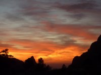
Great sunset in Big Bend NP, Texas
© Utrecht
Big Bend National Park is one of the natural beauties of Texas. The park covers about 1,250 square miles and is located in the western part of the Lone Star State, bordering Mexico where the Rio Grande bends, hence its name. Most of the people visit the Chisos Mountains and Basin, where you will also find the only accommodation within the park proper.
![]()
Biscayne National Park
Biscayne National Park is a U.S. National Park located in southern Florida, south of Miami. The park preserves Biscayne Bay and its offshore barrier reefs. Ninety-five percent of the park is water, and the shore of the bay is the location of an extensive mangrove forest. The park covers 70,00ha and includes Elliott Key, the park's largest island and first of the true Florida Keys, formed from fossilized coral reef. The islands farther north in the park are transitional islands of coral and sand. The offshore portion of the park includes the northernmost region of the Florida Reef, one of the largest coral reefs in the world.
![]()
Black Canyon of the Gunnison National Park
Black Canyon of the Gunnison National Park is a United States National Park located in western Colorado and managed by the National Park Service. There are three entrances to the park. The south rim entrance is located 24 kilometres east of Montrose, while the north rim entrance is 18 kilometres south of Crawford and is closed in the winter. The park contains 19 kilometres of the 77-kilometre long canyon of the Gunnison River. The national park itself contains the deepest and most dramatic section of the canyon, but the canyon continues upstream into Curecanti National Recreation Area and downstream into Gunnison Gorge National Conservation Area. The canyon's name owes itself to the fact that parts of the gorge only receive 33 minutes of sunlight a day, according to Images of America: The Black Canyon of the Gunnison. In the book, author Duane Vandenbusche states, "Several canyons of the American West are longer and some are deeper, but none combines the depth, sheerness, narrowness, darkness, and dread of the Black Canyon.
![]()
Bryce Canyon National Park
Bryce Canyon National Park is one of the natural highlights of any visit to the southwest of the USA. Located in the southwest of Utah, this park attracts many visitors inspired by the natural beauty of its famous hoodoos, spires created out of the bigger rocks they once were. The park is open all year round, with most of the crowds visiting during the warmer summer months from May to September.
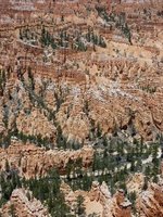
The famous Hoodoos in Bryce Canyon National Park, Utah
© Utrecht
For a more tranquil visit, come in winter, when the 'hoodoos' are sometimes covered with a thin layer of snow. The Rim Road Scenic Drive is 18 miles long with many turnouts and beautiful views. Most of them are on the east side of the road. The Bryce Amphitheater stretches from Bryce Point to Sunrise Point where hoodoos form a great landscape. Sunset and Inspiration point are other highlights. There are dozens of hikes to get closer to the hoodoos, down from the main road. The easiest one is the 0.5 to 5.5-mile-long Rim Trail. Others include the 1-mile Bristlecone Loop, Mossy Cave Trail, Navajo Loop Trail, Queen's Garden Trail, Fairyland Trail and Peekaboo Trail. Backcountry hikes include the 23-mile Under-the-Rim Trail, which can be broken into several day hikes.
![]()
Canyonlands National Park
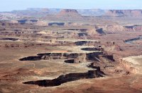
Canyonlands National Park
© Velora
Canyonlands National Park is a U.S. National Park located in southeastern Utah near the town of Moab. It preserves a colorful landscape eroded into countless canyons, mesas, and buttes by the Colorado River, the Green River, and their respective tributaries. Legislation creating the park was signed into law by President Lyndon Johnson on September 12, 1964.
It is divided into three districts not connected by roads interior to the park: the Island in the Sky, the Needles, and the Maze (including Horseshoe Canyon). The Island in the Sky offers sweeping vistas over the lower two districts; the Needles and the Maze are more rugged, backcountry districts that offer excellent backcountry hikes and camping.
![]()
Capitol Reef National Park
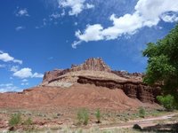
Capitol Reef National Park, Utah
© Utrecht
Capitol Reef National Park is a United States National Park, in south-central Utah. It is 160 kilometres long but fairly narrow. The park, established in 1971, preserves 978.95 km2 and is open all year, although May through September are the most popular months. During this tim the park offers several ranger programs at no charge. These include talks, evening programs at the campground amphitheater and occasional astronomy programs. The park is especially popular amongst hikers, as there are dozens of trails, from easy to strenuous. Check the visitor center for details.
![]()
Carlsbad Caverns National Park
Carlsbad Caverns National Park is located in the Guadalupe Mountains, roughly a 300 miles (almost 500 kilometres) drive from Albuquerque, New Mexico.
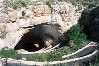
Carlsbad Caverns
© Jrshort
The Caverns date back 200 millions years and the limestone rocks that holds Carlsbad Cavern are full of ocean fossil plants and animals from a time before the dinosaurs, when the southeastern corner of New Mexico was a coastline similar to the Florida Keys. One of Carlsbad Caverns main attraction is the “Big Room” where visitors can go down 900 feet (over 250 metres) in an elevator into the cave's main area and witness the wonderful rock formations. The Carlsbad Caverns are a must-see attraction that gets busy all-year around. Visitors are able to take a self-guided tour or a guided tour and tours can often be set up through hotels in the area and cities nearby. The Caverns are a UNESCO World Heritage site.
![]()
Channel Islands National Park
Channel Islands National Park is a United States national park that consists of five of the eight Channel Islands off the coast of the U.S. state of California, in the Pacific Ocean. Although the islands are close to the shore of densely populated Southern California, their isolation has left them relatively undeveloped. The park covers 100,994 ha of which 31,978 ha are owned by the federal government. The Nature Conservancy owns and manages 76% of Santa Cruz Island, the largest island in the park. Channel Islands National Park is home to a wide variety of significant natural and cultural resources. It was designated a U.S. National Monument on April 26, 1938, and a National Biosphere Reserve in 1976. It was promoted to a National Park on March 5, 1980. Channel Islands National Marine Sanctuary encompasses the waters six nautical miles around Channel Islands National Park.
![]()
Congaree National Park
Congaree National Park preserves the largest tract of old growth bottomland hardwood forest left in the United States. Located in South Carolina, the 107.43 km2 national park received that designation in 2003 as the culmination of a grassroots campaign which had started in 1969. The lush trees growing in this floodplain forest are some of the tallest in the Eastern U.S., forming one of the highest temperate deciduous forest canopies remaining in the world. The Congaree River flows through the park. About 57 percent (61 km2) of the park is designated wilderness area.
![]()
Crater Lake National Park
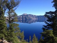
Crater Lake, Oregon
Crater Lake National Park is a United States National Park located in southern Oregon. Established in 1902, Crater Lake National Park is the fifth oldest national park in the United States and the only one in the state of Oregon. The park encompasses the caldera of Crater Lake, a remnant of a destroyed volcano, Mount Mazama, and the surrounding hills and forests. The lake is 592 metres deep at its deepest point, which makes it the deepest lake in the United States, the second deepest in North America and the ninth deepest in the world. The lake's water commonly has a striking blue hue, and the lake is re-filled entirely from direct precipitation in the form of snow and rain. The 33-mile Rim Drive encircles Crater Lake, giving varied perspectives of the lake, rim, and surrounding terrain. Open only during the summer from late June to mid-October, there are many overlooks with interpretive signs. The only access to the lake itself is by steep trail to Cleetwood Cove, where boat tours of the lake are offered.
![]()
Death Valley National Park
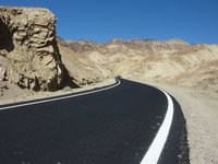
Death Valley Road, California
© Utrecht
Death Valley is located in the Mojave Desert of California in the United States. Although Death Valley basically refers to the valley floor itself, it's actually part of the much larger Death Valley National Park. It is a place of extremes with the driest, hottest, and lowest place in North America. Oddly enough, it is not that far from Mount Whitney, which is the highest point in the lower 48 states. It is a popular camping destination and features many great hiking trails and natural wonders. Though these activities surely are not recommended in the hot summer months unless you plan to hike early in the morning.
![]()
Denali National Park
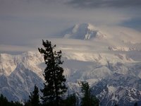
Mt. McKinley (Denali)
© Pamrides
Denali National Park and Preserve is a park located in the central part of Alaska. The park is named after the Denali mountain, the local name for Mount McKinley, the highest mountain in the United States and in fact of North America. The park and preserve together for almost 10,000 square miles of pure nature and wilderness, with loads of trekking opportunities and wildlife as well. Although the park is open year-round, most visitors come to Denali National Park from late May to mid-September. This is the time that all visitor services and activities are available. Mid-June to mid-August is the high season and this is also the time that almost all roads are open, buses operate and trekking is possible. In winter, dogsleds form the main mode of transport, but be prepared for extreme winter weather and most roads are not plowed and only driveable for a few miles into the park. Access into the park and services offered are limited between late September and late April, so be totally self-sufficient during those times.
![]()
Dry Tortugas National Park
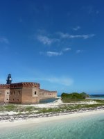
Fort Jefferson, Dry Tortugas National Park
© Utrecht
Dry Tortugas National Park is a national park about 110 kilometres west of Key West in the Gulf of Mexico. The park preserves Fort Jefferson and the seven Dry Tortugas islands, the westernmost and most isolated of the Florida Keys. The archipelago's coral reefs are the least disturbed of the Florida Keys reefs. Fort Jefferson and birdwatching are the highlights here, although there is good snorkelling as well. Visiting the park by private boat is difficult because of its distance, so most visitors come by boat or seaplane from Key West, Florida. Official ferry and transportation services to the Dry Tortugas includes the Yankee Freedom III catamaran and seaplane services. They offer daytrips for US$165 ($120 children), including breakfast, lunch, a tour of Fort Jefferson, snorkelling gear and a great boat trip (usually good weather). Key West Seaplan Charters offers half day and daytrips at (much) higher prices. You can camp at the island for $3 a night but you have to reserve space beforehand, also making sure you book the boatride back.
![]()
Everglades National Park
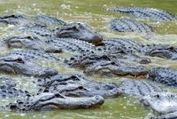
Everglades Gatorade
© zmey
The Everglades encompasses an area of marshland taking up most of the south of Florida. It is a popular tourist destination and the park plays a unique part in local folklore, with legends of moon shiners, smugglers and alligators. The Everglades National Park takes up much of the region. It protects the southern 20% of the original Everglades. In the United States, it is the largest subtropical wilderness, the largest wilderness of any kind east of the Mississippi River, and is visited on average by one million people each year. It is the third-largest national park in the lower 48 states after Death Valley and Yellowstone. It has been declared an International Biosphere Reserve, a World Heritage Site, and a Wetland of International Importance, one of only three locations in the world to appear on all three lists. There are many things to do, including a tram tour at Shark Valley, boat trips from the Gulf Coast Visitor Center (10,000 islands reserve) and Flamingo and beautiful hikes, including the Anhinga Trail.
![]()
Gates of the Arctic National Park
Gates of the Arctic National Park and Preserve is a U.S. National Park in Alaska. It is the northernmost national park in the U.S. (the entirety of the park lies north of the Arctic Circle) and the second largest at 3,428,702 ha, slightly larger in area than Belgium. The park consists primarily of portions of the Brooks Range of mountains. It was first protected as a U.S. National Monument on December 1, 1978, before becoming a national park and preserve two years later in 1980 upon passage of the Alaska National Interest Lands Conservation Act. A large part of the park is protected in the Gates of the Arctic Wilderness which covers 2,900,460 ha. The wilderness area adjoins the Noatak Wilderness Area and together they form the largest contiguous wilderness in the United States.
![]()
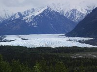
Glacier Bay National Park
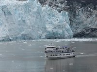
Glacier Bay National Park
© Pamrides
Glacier Bay National Park and Preserve is a United States national park and preserve in the Alaska panhandle west of Juneau. President Calvin Coolidge proclaimed the area around Glacier Bay a national monument under the Antiquities Act on February 25, 1925. Subsequent to an expansion of the monument by President Jimmy Carter in 1978, the Alaska National Interest Lands Conservation Act (ANILCA) enlarged the national monument by 2116.5 km2 on December 2, 1980 and in the process created Glacier Bay National Park and Preserve, with 230.7 km2 of public land designated as national preserve to the immediate northwest of the park in order to protect a portion of the Alsek River and related fish and wildlife habitats while allowing sport hunting.
![]()
Glacier National Park
Perhaps one of the better known attractions in Montana, Glacier National Park, together with Waterton Lakes National Park (across the border in Canada) is a World Heritage Sight in northwestern Montana.
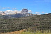
Chief Mountain, Glacier National Park
© berhbs
Glacier National Park is a nature lover's paradise, and apart from a handful of lodges and private inns, you won't find any towns, hotel chains or shops and stores. While the visitor's centers can get crowded at times, there are over a million acres of wilderness (not including Waterton Lakes, adjacent to Glacier on the Canadian side) to get lost in (but please don't get lost).
![]()
Grand Canyon National Park
The Grand Canyon is one of the most popular tourist sights in the world with over 5 million visitors a year. The Colorado River and its tributaries created the Grand Canyon by moving through the sandy soil of the desert. Most of the Grand Canyon is located within the Grand Canyon National Park within Arizona, although parts of the canyon are in Utah and in several Indian Reservations.
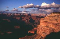
Grand Canyon
© doublet
The canyon is believed to be over 17 million years old and cutting through 2 billion of years of history. The Grand Canyon is 443 kilometres long and ranges in width of 6.4 to 9.6. At its deepest point the Grand Canyon is more than a mile (1.6 kilometres) deep! Hiking, ruins and beauty are the main sights of the Grand Canyon. Some tourists only spend 45 minutes at the Grand Canyon and that is a shame. You can spend days and weeks just hiking the few trails near the South or North Rim. For the more hardcore person with the proper gear, backcountry permits are easy to get. People have spent weeks trekking along the Grand Canyon enjoying its beauty and solitude. Another popular activity is to white water raft the Grand Canyon. This takes lots of planning and fair amount of money. It takes over a year to plan and it is possible to do the whole river or just the sections north or south of Phantom Ranch, which is roughly in the middle of the Grand Canyon. It is a trip of a lifetime and worth every penny. The trip allows you to see the more remote sections of the canyon and experience a part of it that most people in the world will never get to see.
![]()
Grand Teton National Park
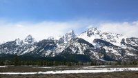
Grand Teton Mountain range
© paix
Grand Teton National Park is located in the northwest of Wyoming, south of worldfamous Yellowstone National Park, its big neighbour. The park was established much later though compared to Yellowstone, only in 1929. Although Grand Teton can be visit as a daytrip from Yellowstone if you are short on time, spending a week alone is possible as well, especially if you go on one of the beautiful backcountry hikes.
![]()
Great Basin National Park
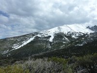
Great Basin National Park, Nevada
© Utrecht
Great Basin National Park is a United States National Park located in White Pine County in east-central Nevada, near the Utah border. The park was established in 1986 and derives its name from the Great Basin, the dry and mountainous region between the Sierra Nevada and the Wasatch Mountains. Topographically, this area is known as the Basin and Range Province. The park is located approximately 470 kilometres north of Las Vegas and protects 31,230 ha. The park is notable for its groves of ancient bristlecone pines, the oldest known non-clonal organisms; and for the Lehman Caves at the base of 3,982-metre Wheeler Peak.
![]()
Great Smoky Mountains National Park
The Great Smoky Mountains National Park
© martgina
The Great Smoky Mountains National Park celebrated its 75th Anniversary in 2009. Over 9 million people visit the park each year, making it the most visited park in the United States. There are 78 historic buildings in the Park, which is open year round. Spanning the borders of North Carolina and Tennessee, the Park is a popular destination for hikers. The Park is a UNESCO World Heritage Site. There is a lot to do and see in the park. The Appalachian Trail is a 2,175 miles (3,500 kilometres) long hiking trail with a section in The Great Smoky Mountains National Park. The park is home to 1,500 black bears who can often been seen in open areas such as Catalooche Valley and Cades Cove. Deer, wild turkeys and foxes are found at Cades Cove. Over 10,000 species have been identified as living in the Park, with the expectation that another 90,000 remain to be found.
![]()
Great Sand Dunes National Park
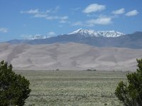
Great Sand Dunes NP, Colorado
© Utrecht
The Great Sand Dunes National Park is located in southern Colorado and is one of the latest national parks created, in 2004. Before that it was a National Monument. Compared to many other national parks in the country, including the most famous two in Colorado, Rocky Mountain National Park and Mesa Verde National Park, the park is not visited that often. Still, it's a popular place to hang out for half a day or more if you are keen on taking longer hikes. Most of the sand originated in the San Juan Mountains, about 65 miles to the west. Wind and water are the primary movers of the sand. Streams, creeks, melting snows and flash floods brought bits of rock out of the mountains to the valley floor. Southwesterly winds then began the slow process of bouncing the sand toward the low curve of the Sangre de Christo Mountains. There they pilled up at the base of the mountains or dropped into creeks to be washed back out toward the valley floor. Although research is still continuing, most researchers agree that the situation is like this at least for 12,000 years but probably much longer.
![]()
Guadalupe Mountains National Park
Guadalupe Mountains National Park is located in the Guadalupe Mountains in the west of Texas and contains the highest peak of the state: Guadalupe Peak at 8,749 feet (2,667 metres).
![]()
Haleakala National Park
Haleakala National Park is a national park located on the island of Maui in the U.S. state of Hawaii. The park covers an area of 134.62 km2 of which 77.98 km2 is a wilderness area. It was originally created as part of the Hawaii National Park along with the volcanoes of Mauna Loa and Kilauea on the island of Hawaiʻi in 1916. Hawaii Volcanoes National Park was made into a separate national park in 1961. The park area was designated an International Biosphere Reserve in 1980. The name Haleakalā is Hawaiian for "house of the sun."
![]()
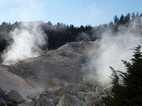
Hawaii Volcanoes National Park
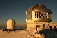
2 of the 14 Observatories on Mauna Kea
In Hawaii Volcanoes National Park on the Big Island of Hawaii, you can see the only active volcano in North America. Here are steaming vents and gleaming black rocks, the results of 70 million years of volcanism, migration, and evolution - processes that thrust a bare land from the sea and clothed it with unique, exotic, tropical ecosystems and a distinct human culture. The park highlights two of the world's most active volcanoes, and offers insights on the birth of the Hawaiian Islands as well as world-famous views of dramatic volcanic landscapes. An experience visiting the volcano on the Big Island has two parts. There is the steaming Kilauea crater at nearly 4,000 metres high as well as the long slope near Kalapana where the molten lava goes into the ocean. Watching earth being created is an experience you will never forget and is best done near sunset. Hawaii Volcanoes National Park is only one of several astounding natural features on the Big Island of Hawai'i. You can also find Mauna Kea, the world's tallest peak as measured from base to summit, sacred Waipi'o Valley with its lush flora and black sand beach, and eleven of the world's thirteen climate zones in one area of the island or another.
![]()
Hot Springs National Park
Hot Springs National Park is a United States National Park in central Garland County, Arkansas, adjacent to the city of Hot Springs, the county seat. Hot Springs Reservation was initially created by an act of the United States Congress on April 20, 1832 to be preserved for future recreation. Established before the concept of a national park existed, it was the first time that a piece of land had been set aside by the federal government to preserve its use as an area for recreation. It is the smallest national park by area in the United States. Since Hot Springs National Park is the oldest park maintained by the National Park Service, it was rightfully the first to receive its own US quarter in April 2010 as part of the America the Beautiful Quarters coin series.
![]()
Isle Royale National Park
Isle Royale National Park is a U.S. National Park on Isle Royale and adjacent islands in Lake Superior, in the state of Michigan. Isle Royale National Park was established on April 3, 1940, designated as a National Wilderness Area in 1976, and made an International Biosphere Reserve in 1980. The park covers 894 2,320 km2, with 540 km2 above water. At the U.S.-Canada border, it meets the borders of the future Canadian Lake Superior National Marine Conservation Area.
![]()
Joshua Tree National Park
Located deep in the southern Californian desert is Joshua Tree National Park. Designated as a National Park in 1994 this area is one of the best preserved desert areas in the country. The park covers two different deserts that have their own ecosystem that are determined by different elevations. The area below 3,000 feet (900 metres), is in the Colorado Desert and the plant life is creosote bush, ocotillo and cholla cactus. The Little San Bernardino Mountains cut through the southern park of the park.
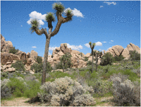
Joshua Tree
© airwaves
The higher, and therefore moister, part of the park is in the cooler Mojave Desert. This part of the park is home to the namesake of the park the Joshua Tree (Yucca brevifolia), which is related to the yucca plant. There are also several bird species to watch for in the park, with the best place to watch being Barker Dam. The dam is a also a good spot to watch for Big Horn sheep. The Mojave Desert part of the park, in the western part, is also home to amazing geologic formations. These bare rocks are broken up into loose boulders that are home to the parks most popular activity of rock climbing. Many people descend upon the park during the fall and spring, which is the high season, in order to take part in some of the best rock climbing in the world.
![]()
Katmai National Park
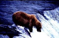
Brooks Camp Katmai NP
Katmai National Park and Preserve is a United States National Park and Preserve in southern Alaska, notable for the Valley of Ten Thousand Smokes and for its Alaskan brown bears. The park and preserve covers 16,564.09 km2, being roughly the size of Wales. Most of this is a designated wilderness area in the national park where all hunting is banned, including over 1,587,000 ha of land. The area was first designated a national monument in 1918 to protect the area around the major 1912 volcanic eruption of Novarupta. The park includes as many as 18 individual volcanoes, seven of which have been active since 1900. Bears are everywhere in Katmai. Few places on earth have as many bears as Katmai or offer comparable bear viewing opportunities.
![]()
Kenai Fjords National Park
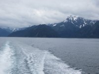
Kenai Fjords National Park
Kenai Fjords National Park is a United States National Park established in 1980 by the Alaska National Interest Lands Conservation Act. The park covers an area of 2,711km2 on the Kenai Peninsula in southcentral Alaska, near the town of Seward. The park contains the Harding Icefield, one of the largest ice fields in the United States. The park is named for the numerous fjords carved by glaciers moving down the mountains from the ice field. The field is the source of at least 38 glaciers, the largest of which is Bear Glacier. The park lies just to the west of Seward, a popular port for cruise ships. Exit Glacier is reachable by road and is a popular tour destination. The remainder of the park is primarily accessible by boat. The fjords are glacial valleys that have been submerged below sea level by a combination of rising sea levels and land subsidence.
![]()
Kobuk Valley National Park
Kobuk Valley National Park is in northwestern Alaska 40 kilometres north of the Arctic Circle. It was designated a United States National Park in 1980 by the Alaska National Interest Lands Conservation Act. It is noted for the Great Kobuk Sand Dunes and caribou migration routes. The park offers backcountry camping, hiking, backpacking, and dog sledding. There are no designated trails or roads in the park, which at 7,084.90 km2, is approximately the size of the state of Delaware. The park is entirely above the Arctic Circle.
![]()
Lake Clark National Park
Bears at Lake Clark Wilderness
Lake Clark National Park and Preserve is a United States National Park in southwestern Alaska. It was first proclaimed a national monument in 1978, then established as a national park and preserve in 1980 by the Alaska National Interest Lands Conservation Act. The park includes many streams and lakes vital to the Bristol Bay salmon fishery, including its namesake Lake Clark.
![]()
Lassen Volcanic National Park
Lassen Volcanic National Park, California
© Utrecht
Lassen Volcanic National Park is a United States National Park in northeastern California. The dominant feature of the park is Lassen Peak, the largest plug dome volcano in the world and the southern-most volcano in the Cascade Range. Lassen Volcanic National Park started as two separate national monuments designated by President Theodore Roosevelt in 1907: Cinder Cone National Monument and Lassen Peak National Monument.
![]()
Mammoth Cave National Park
Mammoth Cave National Park is a United States National Park and a UNESCO World Heritage Site in Kentucky's Caves and Lakes region. It preserves the world's longest known cave system, with over 392 miles of caves. The park was established in 1941 and currently draws nearly two million visitors annually. Mammoth Cave National Park is home to over 70 threatened, endangered or state listed species. More than 130 species are regular inhabitants of the caves. These species are divided almost equally among three classes of cave life: obligate cave dwellers known as troglobites, facultative species which can complete their life cycle in or out of caves (troglophiles), and those that use caves for refuge (trogloxenes). The Park has cave species and biotic cave communities that are among the most diverse in the world. Because of its diverse array of landscapes and habitats, the Park contains an extraordinary 1,300 species of plants.
![]()
Mesa Verde National Park
Ever see the picture of Cliff Palace in the American Southwest and wonder, where in the world is that? Mesa Verde National Park is where the majority of easy to access cliff dwellings are located and is a UNESCO World Heritage Site.
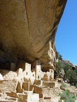
Cliff Palace, Mesa Verde National Park, Colorado
© Utrecht
These stunning homes were built in cliff alcoves, which were dug out by natural springs, in the sides of canyons of Mesa Verde near present day Cortez (Colorado). The builders of these amazing towns are the ancestors of the current day Pueblo People that live further south in current day New Mexico and Arizona. The ruins at Mesa Verde are considered to part of the Ancestral Pueblo People heritage. In the past, the term Anasazi was used to describe the inhabitants of these ruins. This is no longer a proper term because Anasazi is actually a Navajo word that means “ancient enemies.” Current day Pueblo peoples find the term Anasazi offensive.
![]()
Mount Rainier National Park
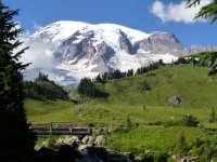
Mount Rainier National Park, Washington State
© Utrecht
Mount Rainier is an active and massive stratovolcano in the state of Washington, 87 kilometres southeast of Seattle. It is the highest peak of the Cascade Range with 4,392 metres. Mount Rainier and the surrounding area were declared a national park which is known under the name: the Mount Rainier National Park. With 26 major glaciers Mount Rainier is the most heavily glaciated peak in the USA, if you would exclude Alaska. In the past large scaled mudflows caused devastation in the area of the volcano. The last major eruption was in 1894. A trip to the top of the mountain can only be made by people that have experience is climbing on glaciers and snowfields. The ascent takes two to three days. On clear days the mountain can be seen from as far as Portland and Seattle. Mount Rainier is considered one of the most dangerous volcanoes in the world, and it is on the so-called Decade Volcano list, which refers to the 16 volcanoes identified by the International Association of Volcanology and Chemistry of the Earth's Interior (IAVCEI) as being worthy of particular study in light of their history of large, destructive eruptions and proximity to populated areas. [1]. Because of its large amount of glacial ice, Mount Rainier could potentially produce massive lahars that would threaten the whole Puyallup River valley.
![]()
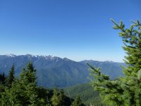
North Cascades National Park
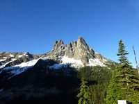
North Cascades National Park view
North Cascades National Park is a U.S. National Park located in the state of Washington. The park is the largest of the three National Park Service units that comprise the North Cascades National Park Service Complex. Several national wilderness areas and British Columbia parkland adjoin the National Park. The park features rugged mountain peaks and protects portions of the North Cascades range. Sitting on the border of the United States and Canada, the North Cascades National Park covers an area of over 500,000 acres and ranges between 300 and 3,000 metres above sea level. Much of the park is designated as "wilderness," and there are few areas with developed facilities. It is quite close to Bellingham and Seattle, however, providing easy access from urban areas. The park is divided into two non-contiguous sections to the north and south of the North Cascades Highway (State Route 20). Non-hikers are limited to the view from the highway, and a few side roads.
![]()
Olympic National Park
Olympic National Park, Washington State, USA
© Utrecht
Olympic National Park is a national park located in the state of Washington, USA. The park has four basic regions: the Pacific coastline, alpine areas, the west side temperate rainforest and the forests of the drier east side. U.S. President Theodore Roosevelt originally created Mount Olympus National Monument in 1909. It was designated a national park by President Franklin Roosevelt on June 29, 1938. In 1976, Olympic National Park became an International Biosphere Reserve, and in 1981 it was designated a World Heritage Site. In 1988, Congress designated 95% of the park as the Olympic Wilderness.
![]()
Petrified Forest National Park
Petrified Forest National Park is a United States national park in Navajo and Apache counties in northeastern Arizona. Named for its large deposits of petrified wood, the fee area of the park covers about 440 square kilometres, encompassing semi-desert shrub steppe as well as highly eroded and colorful badlands. The park's headquarters is about 42 kilometres east of Holbrook along Interstate 40 (I-40), which parallels the BNSF Railway's Southern Transcon, the Puerco River, and historic U.S. Route 66, all crossing the park roughly east–west. The site, the northern part of which extends into the Painted Desert, was declared a national monument in 1906 and a national park in 1962. About 800,000 people visit the park each year and take part in activities including sightseeing, photography, hiking, and backpacking.
![]()
Pinnacles National Park
Pinnacles National Park is a U.S. National Park protecting a mountainous area located east of the Salinas Valley in Central California, 8 kilometres east of Soledad and 130 kilometres southeast of San Jose. The park's namesakes are the eroded leftovers of the western half of an extinct volcano that has moved 320 kilometres from its original location on the San Andreas Fault, embedded in a portion of the California Pacific Coast Ranges. Pinnacles is managed by the National Park Service and the majority of the park is protected as wilderness. The national park is divided by the rock formations into East and West Divisions, connected by foot trails; there is no through road that connects the east and west entrances to the park. The east side has shade and water, the west has high walls. The rock formations provide for spectacular pinnacles that attract rock climbers. The park features unusual talus caves that house at least thirteen species of bat. Pinnacles is most often visited in spring or fall because of the intense heat during the summer months. Park lands are prime habitat for prairie falcons, and are a release site for California condors that have been hatched in captivity.
![]()
Redwood National Park
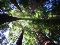
Redwood circle
The Redwood National and State Parks (RNSP) are located in the United States, along the coast of northern California. Comprising Redwood National Park (established 1968) and California's Del Norte Coast, Jedediah Smith, and Prairie Creek Redwoods State Parks (dating from the 1920s), the combined RNSP contain 540 km2. Located entirely within Del Norte and Humboldt Counties, the four parks, together, protect 45% of all remaining coast redwood (Sequoia sempervirens) old-growth forests, totaling at least 157.75 km2. These trees are the tallest and one of the most massive tree species on Earth. In addition to the redwood forests, the parks preserve other indigenous flora, fauna, grassland prairie, cultural resources, portions of rivers and other streams, and 60 kilometres of pristine coastline.
![]()
Rocky Mountain National Park
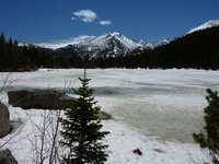
Frozen Bear Lake, Rocky Mountain NP, Colorado
© Utrecht
Rocky Mountain National Park in northern Colorado was USA's tenth national park, a status it achieved in 1905. The park is approximately 25 miles (40 kilometres) from north to south and 20 miles (32 kilometres) east to west and covers a particularly wild and scenic part of the Colorado Rockies. Much of the area is over 12,000 feet (over 3,600 metres) above sea level and here the landscape resembles the arctic tundra. Main access is via Estes Park on the eastern side and the smaller Grand Lake on the west. These are the only towns bordering the region and both offer a good choice of accommodation. As its name suggests, the main feature of the park are the Rocky Mountains themselves with the continental divide ridge passing more or less through the middle of the park. The rivers on the eastern side flow eventually to the Atlantic while for those on the west, the Pacific is a final destination. The only road in the park to cross the divide is Trail Ridge which does so at Milner Pass. The altitude varies from just over 7,000 feet (over 2,100 metres) around Estes Park to over 14,000 feet (over 4,200 metres) at the summit of Longs Peak.
![]()
Saguaro National Park
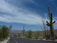
Saguaro National Park, Arizona
© Utrecht
The Saguaro National Park was created to preserve the Giant Saguaro cacti, which only grows in the Sonoran Desert. The park consists of two districts: the Tucson Mountain District, about 24 kilometres west of Tucson, and the Rincon Mountain District, about 32 kilometres east of Tucson.There are over 250 kilometres of hiking trails throughout the park, but you can just as easily just make a nice early morning or late afternoon drive along well maintained roads. The Rincon Mountain District is the most popular and includes the land protected in the original National Monument. Plant communities at the lower elevations in the park are typical of the Sonoran Desert, while the Rincon Mountains support a temperate coniferous forest. The highest peak in this range is Mica Mountain, at an elevation of 2,641 metres. While this side of the park has fewer saguaro than its counterpart they are larger in size, due to higher amounts of rainfall and run off from the Rincon Mountains. The key feature of this district is its 13.4 kilometre loop road, which provides access to the two picnic areas and the central trails.
![]()
Sequoia National Park
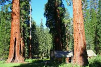
Sequoia National Park
© katze06
Sequoia National Park is a national park in the southern Sierra Nevada east of Visalia, California, in the United States. It was established on September 25, 1890. The park spans 1,635.18 km2. Encompassing a vertical relief of nearly 4,000 metres, the park contains among its natural resources the highest point in the contiguous 48 United States, Mount Whitney, at 4,421 metres above sea level. The park is south of and contiguous with Kings Canyon National Park; the two are administered by the National Park Service together as the Sequoia and Kings Canyon National Parks.
![]()
Shenandoah National Park
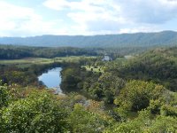
One fork of Shenandoah River.
© jcorilio
Shenandoah National Park encompasses part of the Blue Ridge Mountains in the U.S. state of Virginia. The Park headquarters are located in Luray. This national park is long and narrow, with the broad Shenandoah River and Valley on the west side, and the rolling hills of the Virginia Piedmont on the east. Although the scenic Skyline Drive is likely the most prominent feature of the Park, almost 40% of the land area has been designated as wilderness and is protected as part of the National Wilderness Preservation System. The highest peak is Hawksbill Mountain at 1,235 metres. The park is best known for Skyline Drive, that runs the entire length of the park along the ridge of the mountains. The drive is particularly popular in the fall when the leaves are changing colors. Over 160 kilometres of the Appalachian Trail are also in the park. In total, there are over 800 kilometres of trails within the park. Of the trails, one of the most popular is Old Rag Mountain, which offers a thrilling rock scramble and some of the most breathtaking views in Virginia. There is also horseback riding, camping, bicycling, and many waterfalls. The Skyline Drive is the first National Park Service road east of the Mississippi River listed as a National Historic Landmark on the National Register of Historic Places. It is also designated as a National Scenic Byway.
![]()
Theodore Roosvelt National Park
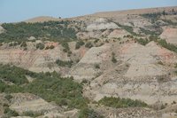
Theodore Roosevelt Park, Medora, ND
© kirkleak
Theodore Roosevelt National Park is a United States National Park comprising three geographically separated areas of badlands in western North Dakota. The park was named for U.S. President Theodore Roosevelt. The scenery changes constantly in relationship with the seasons. Both main units of the park have scenic drives, approximately 100 miles of foot and horse trails, wildlife viewing, and opportunities for back country hiking and camping. One of the most popular attractions is wildlife viewing. The park is home to a wide variety of Great Plains wildlife including bison, feral horses, elk, bighorn sheep, white-tailed deer and mule deer, prairie dogs, and at least 186 species of birds including golden eagles, sharp-tailed grouse, and wild turkeys. Bison may be dangerous and visitors are advised to view them from a distance. Bison, elk, and bighorn sheep have been successfully reintroduced to the park.
![]()
Virgin Islands National Park
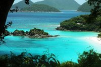
vergini americane
The Virgin Islands National Park is a well maintained park with kilometres of beautiful shorelines, pristine reefs, hiking trails and tropical birdlife on Saint John. Over 30 species of birds have been recorde within the park's boundaries, including some species like the bananaquit, hummingbirds and smooth-billed ani. This is also an example of an area that was logged during the 18th century but has regained the tropical nature it used to have including a mix of introduced species and native plants.
![]()
Voyageurs National Park
Voyageurs National Park is a United States National Park in northern Minnesota near the town of International Falls established in 1975. The park's name commemorates the voyageurs, French-Canadian fur traders who were the first European settlers to frequently travel through the area. The park is notable for its outstanding water resources and is popular with canoeists, kayakers, other boaters, and fishermen. The Kabetogama Peninsula, which lies entirely within the park and makes up most of its land area, is accessible only by boat. To the east of the National Park lies the Boundary Waters Canoe Area Wilderness. The park has several boat ramps and visitor centers on its periphery, though the main body of the park is only accessible by boat or, in the winter, by snowmobile, ski, or snowshoe. In 2016, the park hosted 241,912 visitors.
![]()
Wind Cave National Park
Wind Cave National Park is a United States national park 16 kilometres north of the town of Hot Springs in western South Dakota. Established in 1903 by President Theodore Roosevelt, it was the seventh U.S. National Park and the first cave to be designated a national park anywhere in the world. The cave is notable for its displays of the calcite formation known as boxwork. Approximately 95% of the world's discovered boxwork formations are found in Wind Cave. Wind Cave is also known for its frostwork. The cave is also considered a three-dimensional maze cave, recognized as the densest cave system in the world. The cave is currently the sixth-longest in the world with 226 kilometres of explored cave passageways, with an average of four new miles of cave being discovered each year.[citation needed] Above ground, the park includes the largest remaining natural mixed-grass prairie in the United States.
![]()
Wrangell-St. Elias National Park
St. Elias
Wrangell–St. Elias National Park and Preserve is a United States national park and national preserve managed by the National Park Service in south central Alaska. The park and preserve was established in 1980 by the Alaska National Interest Lands Conservation Act. This protected area is included in an International Biosphere Reserve and is part of the Kluane/Wrangell-St. Elias/Glacier Bay/Tatshenshini-Alsek UNESCO World Heritage Site. The park and preserve form the largest area managed by the National Park Service in the United States by area with a total of 53,320.57 km2. The park includes a large portion of the Saint Elias Mountains, which include most of the highest peaks in the United States and Canada. Wrangell-St. Elias borders on Canada's Kluane National Park and Reserve to the east and approaches the U.S. Glacier Bay National Park to the south. The chief distinction between park and preserve lands is that sport hunting is prohibited in the park and permitted in the preserve. In addition, 3,674,009 ha of the park are designated as the largest single wilderness in the United States.
![]()
Yellowstone National Park
Yellowstone National Park is one of the most famous natural parks in the world. With over 2 million visitors each year and covering more then 8,983 square kilometres (3,468 square miles) this wilderness area is amazing. The park is mainly in the state of Wyoming (96%), although parts cross into Montana (3%) and Idaho (1%).
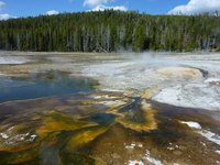
Yellowstone colours
© Utrecht
The park has a diversity of land formations such as lakes, canyons, mountains and rivers. There are also countless animal and plant species within the park including several endangered species like grizzlies, wolves and bison. Other animals include black bears, elk, beavers, squirrels and numerous species of birds and birds of prey. What draws most people to the park is more then its stunning beauty and animals. The park is the center of amazing geothermal activity. Over half the world's geothermal features are located within Yellowstone and are still fueled by massive volcanic powers. Some of these geysers, or small volcanoes, have become very popular. If looking for an intense back country experience or just driving the parks roads in a RV there is something for any group of travelers in Yellowstone National Park.
![]()
Yosemite National Park
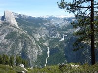
Spectactular view from Glacier Point Road, Yosemite NP
© Utrecht
Yosemite National Park is a massive national park, with 95% designated as a wilderness area, covering over 761,266 acres in several counties in east central California. Over 3.5 million people visit this park every year to see its stunning beauty. Its main attractions are its amazing granite cliffs, waterfalls, pristine streams, Giant Sequoia groves and stunning biological diversity. Resting across the Sierra Nevada Mountains the elevation ranges from 600 to 4,000 metres (2,000 feet to 13,114 feet), which covers 5 distinct major vegetation zones. If looking for the drive by experience, car camping fun or the intense back country hiking and rock climbing Yosemite National Park has something for any outdoorsy junkie. Remember to watch out for black bears. The park consists of 5 areas: the Yosemite Valley, Glacier Point Road/Area, Tioga Road and Tuolumne Meadows, Wawona and Hetch Hetchy (the least visited).
![]()
Zion National Park
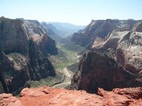
The view down Zion canyon
© JustJ
Zion National Park is one of the highlights of any visit to Utah. It's located in the southwestern corner of the state, not far from the states of Arizona and Nevada. Bryce Canyon National Park is just about 130 kilometres to the east. Together with many other national parks in Utah and northern Arizona, it forms part of a great road trip across the sparsely populated southwest of the United States. Although many say it's less spectacular compared to Bryce Canyon, it's a park with fantastic natural features, including the 24-kilometre-long Zion Canyon, dropping up to half a mile down from its rim. The red and white cliffs tower high above the Virgin River. Other features include rocks, grottoes, hanging gardens, waterfalls, lush riverbanks and meadows. Combined with lower elevation, which means warmer days (and nights), it's totally different from many other parks in the drier east.
![]()
References
Contributors
 Utrecht (100%)
from https://utrecht.travellerspoint.com
United States National Parks Travel Helpers
We don't currently have any Travel Helpers for United States National Parks
This is version 62. Last edited at 8:09 on May 3, 17 by Utrecht. 9 articles link to this page.

Except where otherwise noted, content of this article is licensed under a Creative Commons Attribution-ShareAlike 3.0 License