Kilimanjaro

Travel Guide Africa Tanzania Kilimanjaro
Introduction
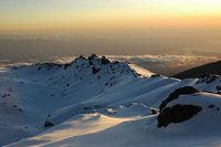
Kilimanjaro Summit
© Fiction
Quoting Ernest Hemingway
As wide as all the world, great, high, and unbelievably white in the sun, was the square top of Mount Kilimanjaro.
Mount Kilimanjaro, at 5,895 metres, is the highest peak in Africa. It also has the distinction of being the tallest free-standing mountain (i.e. not in a mountain range) and the tallest "walkable" mountain in the world.
Mount Kilimanjaro lies on the border of Tanzania and Kenya, just south of the Equator. To the west lies the Great African Rift Valley, created by tremendous tectonic forces which also gave birth to a string of other volcanoes. One of these, Mount Kenya, was originally much higher than Kilimanjaro.
The three summits of Mount Kilimanjaro, Shira, Kibo and Mawenzi are all of very recent origin. Shira and Mawenzi both have suffered considerable erosion and only jagged peaks remain. Kibo, the central, youngest and highest peak has survived as an almost perfect cone.
It is unknown if any of the natives in the area had ever climbed the mountain all the way to the top. Europeans first arriving in the area heard tales of brave souls sent up the mountain to bring back the silver on it's slopes. They reached the silver slopes and gathered up the silver, but upon coming down the mount found the silver had turned to water. Dr. Hans Meyer was the first European to summit the mount on the 5th of October 1889.
![]()
Weather
The climate of Kilimanjaro is influenced by the height of the mountain, which allows the simultaneous influence of the equatorial trade winds and the high altitude anti-trades, and the isolated position of the mountain. Kilimanjaro has daily upslope and nightly downslope winds, a regimen stronger on the southern than the northern side of the mountain. The flatter southern flanks are more extended and affect the atmosphere more strongly.
Kilimanjaro has two distinct rainy seasons, one from March to May and another around November. The northern slopes receive much less rainfall than the southern ones. The lower southern slope receives 800 to 900 millimetres annually, rising to 1,500 to 2,000 millimetres at 1,500 metres altitude and peaking "partly over" 3,000 millimetres in the forest belt at 2,000 to 2,300 metres. In the alpine zone, annual precipitation decreases to 200 millimetres.
Snowfall can occur any time of year but is associated mostly with northern Tanzania's two rainy seasons (November–December and March–May). Precipitation in the summit area occurs principally as snow and graupel (250 to 500 millimetres per year) and ablates within days or years.
The average temperature in the summit area is approximately -7 °C. Nighttime surface temperatures on the Northern Ice Field (NIF) fall on average to -9 °C with an average daytime high temperature of -4 °C. During nights of extreme radiational cooling, the NIF can cool to as low as -15 to -27 °C.
![]()
Getting There and Away
Most people travelling to Kilimanjaro will travel to either Moshi or Arusha. Kilimanjaro International Airport is almost exactly half way between these two cities.
![]()
Arranging Mountain Climbs
Mountain climbs can be arranged in either Moshi or Arusha, or through a tour company in a visitor's home country. Most legitimate tour operators in Tanzania will be members of the Tanzania Association of Tour Operators (TATO).
![]()
Costs
It is required to have a licensed guide to climb Kilimanjaro. Current park entry and camping/hut fees are over US$100 per day. Most climbers are accompanied with porters. All inclusive trips range from about US$800 to US$5,500. Over and above the amount you pay to the tour operator, it is obligatory on the part of the trekkers to pay tips to the guides, cooks and porters who accompany you on the mountain. though there is no set guidelines as to how much you should pay, it is sufficient if you can pay around 10% of the amount you pay to the tour operators with the guide getting the major share and equal distribution of the remaining amount to the porters. since the porters are the least paid by the tour operators and the ones who take the maximum load during the trek, your generosity would be of much help to them. But, it is not advisable to give the whole amount to one person and expect him to distribute it among the others. Chances are high that he may pocket the whole amount. It would be wise to personally hand over the amount to the individual in person. Also, the gear used by the porters is mostly substandard and in fact not at all fit for the trek. It would be generous if you could spare some of your gear if you think you can do it.
![]()
Routes
There are six routes officially sanctioned for climbing Kilimanjaro and two routes used for descent. These are Machame, Marangu, Rongai, Lemosho, Umbwe, Shira and Mweka (descent only). These 6-day schedules are common but too fast – there is a very high risk (75%!) of altitude sickness, and it is quite likely that you will not be able to summit the mountain on these schedules. In order to safely acclimatize, you should ascend more slowly than indicated.
Rongai
Rongai is the only route over on the northeastern side of the mountain, starting close to the Kenyan border. It is not as popular as other routes, probably because it was closed for many years due to border skirmishes between Kenya and Tanzania. The route has re-opened (no more skirmishes) and is gaining popularity. There are no cabins on the Rongai route, so camping is done in tents.
On a 6-day climb, the itinerary would be:
- Day 1 is a 3 to 4 hour climb from Rongai village up to Moorland camp at 2,600 metres, a rise of 650 metres. The climb is through a pine forest, emerging eventually into the moorland.
- Day 2 is a 6 to 7-hour trek rising 1,000 metres up to 3,600 metres to the Kikelewa Caves camp.
- Day 3 climbs from Kikelewa Cave to Mawenzi Tarn Camp, a rise of 730 metres to 4,330 metres in 3 to 4 hours, passing giant senecios trees.
- Day 4 climbs across the saddle between the Kibo and Mawenzi peaks, rising 520 metres before descending 100 metres and ending at 4,750 metres. The trek takes about 4 to 5 hours. The landscape at this high altitude is alpine desert.
- Day 5 starts very early as the drive to the summit happens at night, headed to Gillman's point at 5,735 metres above sea level. This will take 5 to 6 hours switch backing up the loose volcanic scree. Arriving at Gillman's Point the Park Rangers will award you a certificate, but the real goal is still 2 hours ahead, Uhuru Peak at 5,896 metres above sea level. After a short stint at the top, the descent starts right away. From the summit, we descend 2,016 metres to Horombo Huts at 3,720 metres altitude. All told, the summit and the descent will take anywhere from 9 to 15 hours of hiking.
- Day 6], the final day, descends back to Marangu Gate at 1860 metres and then it's a drive back to either Arusha at 1,650 metres or Moshi at 886 metres.
![]()
Health and Safety
Altitude Sickness
Climbers, especially in the later stages of a trek, will likely suffer some form of AMS. Altitude sickness, also known as acute mountain sickness (AMS), is a condition caused by ascending to high altitudes, usually above 2,500 metres. Most people have some effects from altitude, and suffer mildly from AMS. More serious cases can progress into High Altitude Pulmonary Edema (HAPE) or High Altitude Cerebral Edema (HACE).
Some of the companies guiding you to the summit will test your oxygen level and heart rate each evening as you ascend the mountain. A high resting heart rate or an oxygen level below 80% are likely to prevent you from reaching the summit.
For details on symptoms, prevention and cure, see the Altitude Sickness page in the general health section.
![]()
Eat/Drink
Drink a lot of water. Also, a lot of oral rehydration salts (ORS) are recommended for preventing dehydration while trekking on the mountain.
The various food requirements are met by the porters and cooks who come along with you on the mountain. However, the quality of the food depends on the reputation of the Tour Operator you are climbing with. The quality of the food tends to go down towards the end of the trek due to reduction in rations carried by the porters and also due to the food becoming stale by the end of the trek. It is recommended to carry along some High energy food like chocolates and nuts for surviving and successful completion of the trek. It would be worthy enough to carry along some readymade noodle packets etc for cooking them at the end of the trek.
Sleep
Lodging on the mountain is limited to designated camp sites. Cave sleeping is now prohibited. A number of huts are available, but generally not advisable. Pre-climb lodging is generally found in Moshi or Arusha.
It is permitted to camp on Mt Kilimanjaro for as many days as you want by paying the designated fees to the Kilimanjaro national Park authorities and camp in any of the nearest camps like the Machame Hut or the Mweka Hut.
![]()
Accommodation in Kilimanjaro
We have a comprehensive list of accommodation in Kilimanjaro searchable right here on Travellerspoint.
Contributors
 Utrecht (68%)
from https://utrecht.travellerspoint.com GregW (26%)
from Greg Wesson's Esoteric Globe
as well as Borisborough (2%), hasbeen (2%), Peter (1%)
Kilimanjaro Travel Helpers

Resilience
Ask Resilience a question about KilimanjaroWhy We Want to Be Your Travel Helper on Mount Kilimanjaro
At Resilience Expeditions, we believe Mount Kilimanjaro is more than just a destination—it’s a transformative adventure that challenges and inspires. As experts with years of experience guiding climbers, we are passionate about helping you reach Africa’s highest point safely and with confidence.
We are committed to ensuring you have a well-prepared, unforgettable journey. From selecting the perfect route to guiding you through acclimatization and keeping you motivated, we’re with you every step of the way.
Climbing Kilimanjaro isn’t just about summiting—it’s about the incredible experience, breathtaking views, and personal growth along the journey. Let us help you make this adventure truly life-changing.

Wildroot
Ask Wildroot a question about KilimanjaroBecause we have a long experience operating trekking tours on Kilimanjaro
This is version 22. Last edited at 0:32 on May 27, 17 by hasbeen. 18 articles link to this page.

Except where otherwise noted, content of this article is licensed under a Creative Commons Attribution-ShareAlike 3.0 License